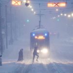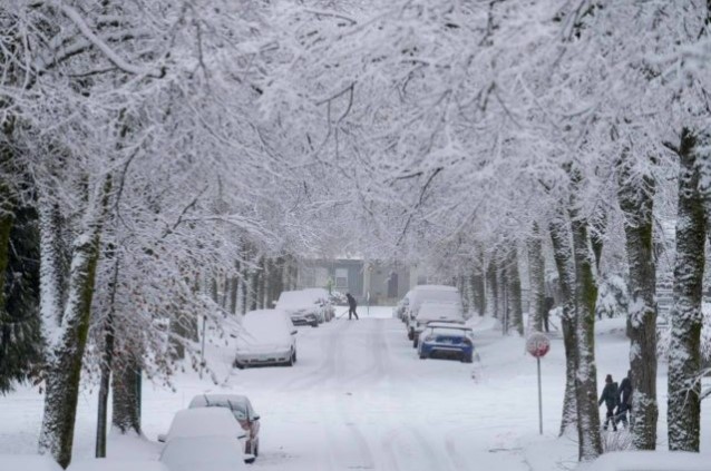
Dec 22, 2022-Vancouver: For the third time this week, the Lower Mainland expects another major snow dump. A robust, very strong storm system hitting Thursday into Friday is expected to blanket the region, which will then be followed by freezing rain, ice pellets and finally, rain to wash everything away in the coming days. Environment and Climate Change Canada (ECCC) has issued a winter storm warning for B.C.’s South Coast, including Metro Vancouver and the Fraser Valley. The weather service warns of “hazardous” winter conditions, including heavy snow, ice pellets, freezing rain, and heavy rain on snow or ice.
ECCC says in its warning, “Visibility will suddenly be reduced to near zero in heavy snow and blowing snow. Localized flooding in low-lying areas is possible. Take extra care when walking or driving in affected areas. Ice build-up may cause tree branches to break.” “This looks very similar to the system that rolled in earlier this week and brought quite a bit of snow. So, I would not be surprised to see some areas picking up 20 to 30 centimetres of snow from this,” he explains. “And then you factor in the wind, it’s going to be difficult, if not impossible, to travel in those whiteout conditions on Friday morning. Then we change it over, possibly to some freezing rain which makes surfaces very slick and then it goes into rain as we head into Friday evening and continuing into Saturday.”
Lam says if you have any errands to run or Christmas presents to buy, do everything during the day Thursday, then go home, bunker down, and consider staying home on Friday.
He says Metro Vancouver will get soaked this weekend with as much as 40 millimetres of rain falling just to get us started before more comes our way next week.
“Once the rain starts to fall, it makes any of the snow that’s fallen extremely heavy and then when we get into Saturday, temperatures warm back up to our seasonal averages, and then we’re going to have melting so that flooding could be a concern,” warns Lam.
The snow and rain are just one part of this; the cold is also a serious concern, with a warning that parts of the Fraser Valley could dip to as low as -30 degrees.
Icy Lower Mainland roads:
With temperatures remaining frigid across the region, some roads are covered with sheets of ice, creating icy conditions for drivers Thursday.
Highway 1 through the Burnaby Lake stretch is one such road, with ice visible from 1,500 feet in the air. Other problem areas include Highway 1 near Whatcom Road in Abbotsford and many hills in and around Vancouver.
Mainland Lower Mainland Contracting, the organization in charge of clearing and maintaining much of the major highways in the Lower Mainland, advises drivers to stay off the roads on Friday.
“There is a high probability that all roadways in the Lower Mainland will become snow-covered this evening, then ice-covered throughout the day on Friday. Travel conditions will be treacherous. Highway closures are likely to occur.
“The public is advised not to use the roadways on Friday unless for emergency reasons.”
Mainland says that when temperatures rise, there will be an “extreme” risk of flooding, as snow covers drain. “Winter weather is unpredictable, be prepared for rapidly changing conditions and please drive to conditions. Ensure your vehicle is prepared with snow tires, a full tank or a full charge, and an emergency kit,”.
Vancouver International Airport appears to be getting back to normal. The airport authority says flights are coming and going, but travellers are still warned to check with their airline before trying to catch their flight.
Things have been a chaotic mess at the airport this week due to the weather. Many people have spent one or more nights sleeping at the terminal after their flight was either cancelled or delayed, with some not knowing when they may get in the air to go home for the holidays. Some frustrated travellers have been reduced to tears as many have said they would like answers from the airline or airport.
TransLink issues warning:
As it has done previously this week, TransLink is asking people not to take transit unless it’s absolutely necessary.
The transit authority says riders should be prepared to wait longer than usual, and there is reduced service for SkyTrain Thursday. Anyone hopping on the train or bus is told to check their route status before heading out.
BC Hydro sets record:
With much of the province under a winter storm warning, BC Hydro is seeing records shatter for power consumption. It broke its second record this week when demand skyrocketed on Wednesday evening.
“Last night’s consumption was more than 15 percent higher than the peak hourly demand recorded last Wednesday before the cold snap began.” “Despite the significant increase, BC Hydro will continue to be able to meet the demand for electricity across the province this winter because of its large integrated hydroelectric system. Residential electricity use is typically at its highest in the colder, darker winter months, which can lead to higher costs for some customers.”
The utility provider asks people to avoid cranking the thermostat, keep their windows covered with blinds or curtains for an extra insulation layer, and seal any drafts to avoid losing heat.